Originally published on Facebook 1 October 2009, written in the wake of the massive flooding triggered by Typhoon Ondoy. This version was published 5 October 2009 on ABS-CBN News.com, as part of a special report on Typhoon Ketsana (Ondoy), and reprinted 27 October 2009 on Focus on the Global South’s Focus on the Philippines.
We need to bring public scrutiny to bear on the big, if hard-to-answer, issues of unsustainable urbanization and land use planning.
It comes as no surprise that public anger in the aftermath of the Ondoy disaster has focused on corruption and incompetence among government officials: on how Arroyo’s Le Cirque dinner could have paid for disaster response equipment; how her son was spotted stocking up on booze even as people were dying in the rising floodwaters; and how unscrupulous politicians were taking advantage of the situation by plastering their grinning mugs all over relief goods. It is, after all, easier to lay responsibilities on names and faces rather than on structural causes.
There is, however, a critical aspect of the issue that evades easy association with names and faces, and is consequently not addressed by the public debate: the problem of untrammeled, private sector-led urbanization.
Whose face do we associate, for example, with the following problems?
1.) As Felino Palafox pointed out, (1) large areas of the east bank of the Marikina River—the exact same areas that were subjected to a massive flash flood—should not have been settled in the first place. Plans that have been drawn up in 1977 called for limits on construction in these areas and public works designed to withstand even the once-in-a-century flooding we saw last weekend.
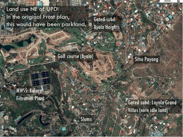
2.) In Quezon City, a ridge along the west bank of the Marikina River, which should have been preserved as a watershed, was paved over as exclusive subdivisions (such as La Vista, Loyola Grand Villas, Blue Ridge, and Ayala Heights), schools (Ateneo de Manila and Miriam College) or settled as slums. In fact, the 1941 Frost Plan for Quezon City identified a protected area on the west bank that stretched from the Batasan area in the north down to Libis in the south.(2) (See maps 1 and 2)

Map 1. The 1941 Frost Plan for Quezon City side-by-side with a satellite image of actual land use. Note the green protected area stretching from the Batasan area (military academy on the plan) all the way to Libis.

Map 2. Actual land use northeast of the UP Diliman campus. Note that in the original Frost Plan, this would have been protected parkland. Instead, it has been transformed into private subdivisions, a golf course, and slums.
Ideally, a forested catchment basin would have prevented flash flooding by maintaining soils with a high absorptive capacity, but as these slopes were graded and paved over for subdivisions, their ability of the soil to retain rainwater was severely compromised.
It is definitely no coincidence that these were perhaps the worst-hit areas in all of Quezon City, where mansions built on slopes unsuitable for residential areas collapsed and entire slums drowned in floodwaters.
3.) Further upstream in the Marikina River system, this process of paving over watersheds is being repeated in new suburban developments in the Sierra Madre foothills of Rizal. Interestingly, at least two presidential aspirants are heavily invested into this process.
I’ll leave it up to you to guess who.
4.) Last but not the least, an altogether more complex problem: a well-meaning policy (3) requires that real estate developers allocate 20% of their “horizontal” house-and-lot developments to socialized housing. However, no such requirement exists for “vertical” condominium developments.
In addition, land prices in the metro area are ridiculously expensive for our level of economic development. Between 1975 and 1991, for example, land prices in Metro Manila grew at a pace of 2.5 to 3.65 times faster than GDP per capita (4). Additionally, newly freed-up parcels (like Fort Bonifacio, Camp Bago Bantay and North Triangle) are typically privatized to the highest bidder.
Given the high price of acquiring urban land, the tendency for developers is to build condominiums for the low-risk, high-return markets of high income demographics. There is absolutely no incentive, whether through our laws or through market forces, to develop high-rise residences in the urban core for the poor majority of the population: effectively denying them, through pricing, the right to legally own property in the urban core.
These factors have two consequences for how Mega Manila grows, how it is built, and how it was affected by tropical storm Ondoy.
The first is the growth of slums in core areas. With land and condominium units effectively priced out of their reach, there is little choice for the urban poor but to live in slums, especially as the market creates conditions for the concentration of 44% of Metro Manila’s land in the hands of the country’s elite families.(5)
The following data demonstrates the extent to which urban poor Filipinos have been systematically abandoned by the state and shunned by the market. We have roughly the same GDP per capita as Indonesia; however, 44% of urban Filipinos live in slums, compared to 23% of urban Indonesians. (6)
| Slum % urban population (2003) | GDP/capita (PPP$) (2008) | |
| Philippines | 44.1 | 3,510 |
| Indonesia | 23.1 | 3,975 |
As the events of the past weekend show, slums are disproportionately vulnerable to natural disasters, as they are often built on marginal land and have high population densities.(7)
The second consequence is sprawl: the city grows out, rather than up. To tap demographics that are priced out of core urban lands, as well as to meet the government’s 20% socialized housing requirement, developers opt to build house-and-lot subdivisions in the urban periphery, where land is still relatively cheap, and where old landlords are eager to dispose of properties about to be subjected to agrarian reform.
This is despite the fact that a significant proportion of land in Metro Manila are in the form of idle, vacant lots. Most neighborhoods in northern Quezon City, where I live, are patchworks of sprawling “exclusive” subdivisions, slum colonies, and idle lots as land bank.
Thus, within the past two decades, Manila’s metropolitan area, as defined by a population density of at least 1,000 persons per square kilometer, has grown to become a 3,105 sq. km. monstrosity, with much of this growth occurring as encroachment on prime agricultural land in Bulacan, Cavite, and Laguna. (8)
This worsened the extent of this weekend’s disaster by expanding the land area affected. With a larger land area to cover, transportation and communications for the relief effort was more difficult than it should have been, and the need to coordinate between different local governments prevented a quicker response.
More importantly, most of the growth occurs in suburban and peri-urban areas that do not have the infrastructure, manpower, and equipment to address these sorts of disasters. Keep in mind that some of the most hard-hit areas, such as Marilao in Bulacan, Biñan in Laguna, and San Mateo, Rodriguez and Cainta in Rizal fit this description perfectly: suburban areas that have seen explosive urbanization but did not see a corresponding improvement in infrastructure and local government capacity.
We therefore end up with a city that is more prone to natural disasters than it should be, in a century that will likely see an out-of-whack ecosystem throwing stronger typhoons and unpredictable monsoons at us.
Now, the hard questions.
Who do we blame for underdevelopment in the countryside? The explosive growth of Mega Manila is directly driven by rural-to-urban migration, as agriculture is no longer a viable livelihood for many Filipinos. Who do we blame for the fact that 62.6% of Filipinos live in cities, compared to 32.5% of Thais? (9) Do we blame the poor for the fact that in the countryside, they are deprived of livelihoods, incomes, and education for their children?
Given our propensity to heap public anger on Jaque Bermejos and UglyYuBins, to publicly shame Mikey Arroyos and Manny Villars, and to present Gloria’s resignation as the solution to what is most definitely a persistent, structural problem, how do we, as a public, come to terms with this situation?
If it’s a matter of laying blame, shouldn’t we also be lining up the Ayalas, the Solivens, and hell, even the Jesuits for developing on lands that should have been preserved as watersheds? Should homeowners shoulder responsibility for creating demand for house-and-lot properties? To stretch the blame game to the point of absurdity: should we demand an official apology from the Americans for exporting the unsustainable house-in-the-suburbs, two-car-garage dream to our country?
And if we do, how would it help the relief efforts? How would the blame game help us arrive at solutions?
If it’s a matter of pinning hopes on our politicians: would a different constitution, a different president, a different NDCC, a different MMDA chair, and different mayors and local government officials translate to substantial changes in how we build our city?
The answers to these questions, I think, are best left to a broad public debate for two reasons.
First, it would get more people thinking and working on solutions. Already, in the wide-ranging conversation generated by the original version of this essay (10), a number of potential solutions have emerged: low-cost housing stock markets; idle land taxation; and transfer of development rights to name a few.
Second, a sustained public clamor is perhaps the only way we can get elected officials to act on a comprehensive solution. Odds are, none of the presidential and mayoral aspirants have a concrete long-term plan for Mega Manila in the 21st century. After all, why build infrastructure that the next mayor would get credit for? If you want to get reelected, it’s much more effective to play the kasal, binyag, at libing patron than to implement a responsible long-term plan.
What the public ultimately needs to do is to create the necessary pressure on elected officials by actively utilizing democratic spaces, by making it clear to elected officials that it is in their best interests to uphold our best interests, as well as the best interests of future generations. Democracy, after all, is not merely a matter of holding a popularity contest every three years.
1. ‘Gov’t, private developers liable for flood damage’
2. Quezon City Government. (2002) Comprehensive Land Use Plan.
3. Urban Development and Housing Act of 1992 (RA 7279)
4. Banzon-Bautista, C. (1998). “Culture and urbanization: The Philippine case.” Philippine Sociological Review, 46(3-4):21-45
5. Berner, E. (1997) Defending a Place in the City: Localities and the Struggle for Urban Land in Metro Manila. Quezon City: Ateneo de Manila University Press
6. Davis, M. (2006) Planet of Slums. London: Verso; World Bank (2009) World Development Indicators database for comparative data on PPP GDP and country populations.
7. Bankoff, G. (2003) Constructing vulnerability: the historical, natural and social generation of flooding in metropolitan Manila.” Disasters, 27(3):224-238; p. 232
8. Jones, G. W. (2005) “Urbanization, megacities and urban planning issues: The Philippines in an Asian context.” Philippine Population Review, 4(1):1-24
9. World Health Organization Statistical Information System.
